
Srishti'19
March 23, 2019

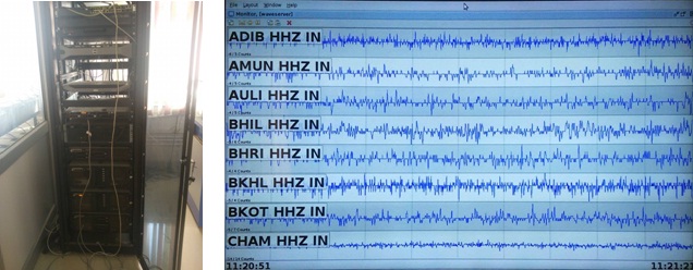
Secluded into a nook, on the third floor of the Biotechnology Department, a computer whizzes away. On the first look, one might have an impression of being in a “Mr. Robot” episode, and when you get to know that the mainframe sitting in front of you is analysing real time data from approximately 80 places, distributed over the northern regions of Uttarakhand, your “Mr. Robot” vibe just grows stronger. Only if it was meant for the same purpose, as going on in our minds. Well, it isn’t.
The newly installed, “Early Warning Earthquake Alarm System,” nicknamed EAS, is an impeccable innovation in the field of disaster management systems. Achieved through concerted efforts from researchers at IIT Roorkee and “Space Dynamics,” a venture by Italian entrepreneurs into the field of “Disaster Mitigation Systems,” the project was executed under the umbrella of Disaster Management and Mitigation Center, Uttarakhand.
Earthquakes, under their current level of understanding, are quite indeterministic in their nature, i.e. one cannot pinpoint the place of origin, time of occurrence, or the intensity of an earthquake. However, EAS, post-analyzing real-time data (shown in the image,) from certain selected earthquake-prone regions, calculates the time that shall be required for the secondary seismic wave to travel between the epicentre and the location under observation. This is known as the “Lead Time.”
Earthquakes begin with primary waves, which move at an average speed of 6 km/s, and are followed by secondary waves, which move at 3 km/s. Ground particles vibrating in the direction of propagation do not tend to cause any damage, however, for the case of secondary waves, one observes particles vibrating perpendicular to the direction of wave propagation. Perpendicular vibrations allow for damage of humongous orders.
A magnitude 7 earthquake, analytically, releases approximately 32 times more energy than a magnitude 6 earthquake. Hence, on the densely populated Gangetic Plains in Uttarakhand, an earthquake with magnitude greater than 7 or 8 has the potential of causing overwhelming damage to human life and property.
To explain the methodology in a brief, seismic sensors have been deployed in tectonically-active areas, and regions which have had a past record of earthquakes. Himalayas, due to the folding and faulting between the Indian and Eurasian tectonic plates, tend to be tectonically-active region. As repercussions of the same, adjacent regions - such as Himachal Pradesh, Uttarakhand, and Nepal - have had an earthquake-fling of their own, with earthquakes of magnitude greater than 8, on richter scale, being observed in the past. Currently, collisions which can lead to disastrous earthquakes, in the aforementioned regions, are being anticipated. This is why, with EAS as a weapon, Seismologists in the state of Uttarakhand have been on a “night watch.”
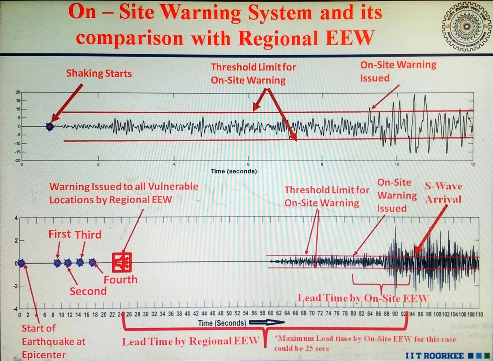
The biggest highlight of EAS is the algorithm that estimates the magnitude of the earthquake in real time simulation, in a matter of 3 seconds, only. Roorkee, being about 120 kms away from the Himalayas, can observe an S-wave in about 40 seconds, if the epicentre of the earthquake lies in Himalayas. After estimation of intensity within 3 seconds, and an additional 10 seconds for an alert to be issued, EAS provides Roorkee with a lead time of about 25-30 seconds. Additionally, warnings shall be issued, only if the magnitude of earthquake exceeds a 6 on the richter scale. Four or more sensors should back the notification, else, no warning is issued. Within the inevitable 10 seconds required for the issuing of warning, the S-wave moves ahead by about 30 km - making this region the blindspot. However, the epicentre is usually a teeny bit into the depths of Himalayas, and, hence, the corresponding blindspot turns out to be a sparsely populated region. Still, an earthquake of magnitude more than 8 can cause some serious havoc in regions reaching upto Delhi.
In recent years, the population in northern Uttar Pradesh has increased significantly, and, more importantly, the entire region sits on soft soil, which tends to amplify wave motion rather than dampen it, hence increasing seismic risk. Fortunately, due to the recent developments in all the nearby villages, broadband network and mobile phones’ connectivity has become very routine. Thus, following the Earthquake emergency measures - post-issuing of the notification - can turn out to be a life-saving choice.